Letak dan Luas
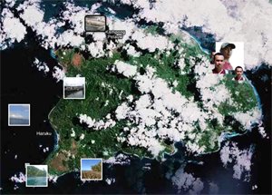
Negeri Hulaliu terletak pada daerah bagian timur pulau Haruku dan berada di daerah pesisir pantai dengan batas wilayah sebagai berikut
Sebelah selatan : Petuanan Hutan Negeri Aboru
Sebelah Utara : Dusun Waimital Petuanan Pelauw
Sebelah Timur : Selat Hulaliu
Sebelah barat : Petuanan Pelauw
Jemaat ini berada pada tanah seluas 25002m
HULALIU from Maplandia.com:
Hulaliu google map
Register at Hulaliu, Center Of Moluccas, Moluccas, Indonesia
Original Name: HULALIU
Geographical Location: Center Of Moluccas , Moluccas, Indonesia, Asia
Geographical Coordinates: 3° 33' 3" South, 128° 33' 59" East.
Original name (with diacritics) of the place is Hulaliu.
See HULALIU photos and images from satellite below, explore the aerial photographs of HULALIU in Hulaliu area.
This placemark was added by Hobert Noya.
Registered to Maplandia by HOBERT NOYA


0 komentar:
Posting Komentar